MPC
Research Projects (2009-10)
Identifying Number
MPC-319
Project Title
Gravel Roads Management: Developing a Methodology
University
University of WyomingProject Investigator
Khaled Ksaibati, University of Wyoming
Phone: (307) 766-6230
E-mail: khaled@uwyo.edu
George Huntington, P.E.
Wyoming T2/LTAP Center
1000 E. University Avenue, Dept. 3295
Laramie, WY 82071
Phone: (307) 766-6783
E-mail: georgeh@uwyo.edu
Description of Project Abstract
Background
Wyoming's public roads are comprised of almost 27,700 miles of highways, but only 25 percent of these roads exist within the state highway system. The remaining mileage belongs to cities and counties and only a small percentage of these are paved with asphalt or concrete. While management systems for asphalt and concrete pavements are varied and sophisticated, those for gravel roads are generally either simple and unrefined or too complex for use by small government agencies. Gravel road surface management systems are available for local governments that allow for entry of a single surface condition variable. Others, such as those developed in South Africa and by the World Bank, require data inputs that are more sophisticated and detailed than most counties in the western USA are capable of collecting. There are no gravel roads management system with significant analytical capabilities that is currently ready for implementation by counties, cities, and towns. Since the majority of Wyoming county road networks have gravel surfaces and many Wyoming municipalities have a high proportion of gravel streets, for an asset management system to provide them with meaningful, comprehensive results, such a system must have the capability to analyze condition data for unpaved roads. A safe, high quality, and efficient transportation system requires consideration of the effective use of resources on the gravel roads making up the vast majority of roadway miles within the state.
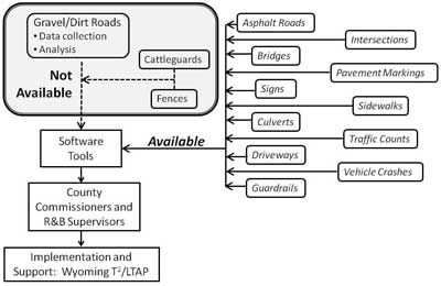
Figure 1 summarizes the current situation with asset management software for unpaved roads. While some asset management components are available for small agencies, there are none that are well-suited to counties that have limited resources and extensive gravel road networks.
Literature Review
Many agencies throughout the United States use highly developed asset management programs. The recent scan report sponsored by the FHWA [1] documents the sophisticated efforts of three local government agencies (LGA) - Hillsborough County, Florida; Kent County, Michigan; and the City of Portland, Oregon - each of which has a population greater than the State of Wyoming. While many Wyoming counties have some sort of asset management system in place, most are very simple. By necessity, these counties need inexpensive analytical procedures to address their most basic funding and budgetary needs.
There are gravel roads models available, such as Highway Development Management-III (HDM-III) and the Highway Development and Management Model (HDM-4), but they are not simple enough for use by many LGAs.
"The Brazilian and HDM-III models are fairly complicated...the usefulness of the models, especially in remote areas, is questionable [2]. The revisions that comprise HDM-4 Version 2 address analytical procedures that are far too sophisticated for use by small counties [3]. In addition, they generally use roughness as a performance measure but most LGAs don't collect roughness data [4]. Gravel road management systems, such as those used in South Africa since 1989, often use data that isn't available to many LGAs. The South African system uses visual distress ratings, layer thickness measurements, Atterberg limits, gradations, and dynamic cone penetrometer (DCP) measurements [5]. Little of this information is available for most Wyoming county roads.
The World Bank has developed a number of analytical software programs for both unpaved and paved roads, primarily for use in developing countries. One of these is the Road User Cost (RUC) spreadsheet, UNEEDS30 (Unpaved Roads Needs 3.0) [6]. The RUC model was developed to accurately assess the financial responsibility of road users for the purpose of establishing reasonable user fees. It determines periodic maintenance costs based on traffic loads and regraveling costs and frequencies. Annual maintenance costs are established based on traffic loads and grading and spot graveling costs and frequencies. Though the economic factors in the Rocky Mountain region and developing countries are very different, the behavior of roads will be similar. Since unit costs are included, this model may be used to generate grading and regraveling costs for unpaved roads in developed countries.
If the RUC software is used without modification, the estimates of the total cost of maintaining unpaved roads will be unrealistically low. Models developed by the Wyoming T2/LTAP Center are designed to present those making budgetary decisions with a comprehensive assessment of a county's unpaved road network's financial needs. As such, costs associated with activities other than simply maintaining the surfacing gravel, such as dust control, drainage repair, plowing snow, and rehabilitation, should be included or policy makers will be presented with artificially low estimates of the true total costs involved in maintaining an unpaved road network.
Several gravel roads data collection techniques are available. One developed by the US Army Corps of Engineers generates an Unsurfaced Road Condition Index (URCI) [7]. This labor-intensive method requires on-the-ground measurement of the following distresses:
- Cross-section (crown)
- Roadside drainage
- Corrugations (washboards)
- Dust
- Potholes
- Loose aggregate
Based on the severity and either the area or density of each of the above distresses, deduct values are determined from charts and an URCI is calculated on a scale of 0 - 100.
Another data collection technique, the PASER method using a 'windshield' survey, was developed by the Wisconsin Transportation Information Center [8].This method assigns a rating of from 1 - Failed to 5 - Excellent for each gravel road segment. (There is a similar manual available for unimproved roads [9].)
Wyoming Technology Transfer Center
In 2007, the Wyoming Technology Transfer Center completed a pilot asset management program. Through extensive planning with Sheridan, Johnson, and Carbon Counties, the Center developed an asset management program. More details on the process the Center went through in establishing the asset management system are presented elsewhere [10].
The Center has also performed a study that attempted to model the performance of gravel roads. The effects of traffic speed and volume, sand to fines ratio, and other factors were evaluated. This is documented more fully elsewhere [11].
The Wyoming T2/LTAP Center used the Gravel PASER Manual as the basis for its data collection. In addition to the single overall rating value described in the PASER manual, the Wyoming T2/LTAP Center rated each of the following distresses individually using a 'windshield' survey:
- Overall
- Potholes
- Rutting
- Washboards (Corrugations)
- Loose aggregate
- Crown (Cross-slope)
- Drainage
- Dust
- Gravel quality
- Gravel quantity
Using the condition data listed above (except for Crown, Gravel Quality, and Gravel Quantity), the Wyoming T2/LTAP Center has developed a method for recommending improvements to road segments. A 'Surfacing Serviceability Index' (SSI) is generated and those roads that are not up to the minimum SSI for their functional class are recommended for improvement. This analytical method requires the following inputs:
- Road segment lengths
- Current surface and drainage conditions
- Functional classes
- Minimum acceptable surface conditions
- Improvement Decision Matrix
- Improvement activity costs
The type of improvement recommended and its associated cost is based on the particular distress severities observed, on functional class, and on an 'Improvement Decision Matrix' developed by the Wyoming T2/LTAP Center.
For further explanation of these processes and to view the final report on the pilot program, one may go to the Wyoming Technology Transfer Center's website [12].
Two other papers by Center staff are in the publication process. One titled 'Annualized Road Works Cost Estimates for Unpaved Roads' will be published in the American Society of Civil Engineers Journal of Transportation Engineering. This paper describes a method using assumed maintenance and rehabilitation frequencies on roads in each of four functional classes along with the mileage in each class to estimate the cost of maintaining a county's unpaved road network. The other titled 'A Methodology for Assessing Heavy Traffic Impacts on Gravel Roads Serving Oil and Gas Drilling Operations' is to be published in the Journal of the Transportation Research Board. It describes the use of the 'improvement recommendations' process described above to compare the performance of roads serving oil and gas drilling to the rest of the roads on the three counties' unpaved road networks. These papers reflect and describe some of the gravel roads asset management lessons learned by Center staff over the past five years.
The Wyoming T2/LTAP Center research activities and the literature search clearly indicate the lack of software that is designed for those responsible for managing an unpaved road network. Since there is currently no widely accepted procedure for managing unpaved roads, software developers are understandably reluctant to invest considerable time and money into programming that will likely need substantial modification before it receives widespread acceptance.
Project Objectives
To address the lack of a widely acceptable methodology for managing unpaved roads, experts in the field will collectively develop a set of criteria for unpaved roads data collection and analysis that will work well for local government agencies with extensive unpaved road networks. This information may then be used by software providers to develop a gravel roads component for an asset management program.
Project Approach/Methods
The following nine tasks will be performed in this study:
- Literature review
- Select expert task group (ETG)
- Coordination with other national efforts
- Initial Meeting
- Prepare preliminary report
- Communicate with other experts in the field by remote methods
- Final Meeting
- Prepare final report
- Present results
Literature Review
A comprehensive review of the literature will be performed in an effort to better assess the state-of-the-practice. Both academic publications and overviews of available software will be examined.
Select Expert Task Group
Seven to ten individuals will be selected to develop the recommended software framework. The following organizations should be represented on the ETG:
- Counties and Municipalities with substantial gravel road and street mileages
- Academia/LTAP
- State DOT
- FHWA
Those selected should have expertise in the following fields:
- Gravel road maintenance
- Gravel road operations
- Budget preparation
- Database management/GIS
- Gravel roads management
In addition to the 7 to 10 members on the ETG, other individuals, perhaps a dozen or so, will be identified who will review and comment on the results of the ETG. These individuals will be communicated with through media such as emails and webinars. This approach will keep the primary ETG small enough to function efficiently while still getting input from a broad base of individuals, particularly end users.
Coordination with Other National Efforts
The National LTAP Association's Training Products and Services workgroup conducted a survey of LTAP and TTAP centers nationally assessing what they perceived as their own greatest training needs. Asset and Pavement Management was at the top of the list. The same survey, with very minor modification, was sent to the National Association of County Engineers' (NACE) Board of Directors. NACE ranked asset and pavement management second, just behind low cost safety improvements. Clearly, asset management is a high priority for local government agencies nationally.
Other LTAP Centers, particularly New Hampshire, Michigan, and Utah, have initiated asset management efforts. The Michigan LTAP Center is in the process of undertaking a similar effort to establish a methodology for gravel roads asset management as directed by Michigan's Transportation Asset Management Council. While this may seem redundant, there are several critical differences between the situation in Michigan and the one in Wyoming and neighboring States:
- Climate: wet and dry climates
- Usage: Gravel roads often serve higher traffic volumes in the west than in the east.
- Maintenance: Routine maintenance of gravel roads is performed on different schedules, depending on the availability of sufficient moisture.
- Materials and Distresses: In drier climates, more binder and moisture retention is needed to minimize dust and washboarding, while in wetter climates aggregate structure and drainage is more critical to minimize rutting and potholes.
- Politics: In Michigan, asset management is mandated by the State legislature, while in Wyoming and most nearby States, participation is at the option of the local government agency.
In spite of these differences, it is expected that there will be many common aspects of the systems recommended by this effort and by the effort to be undertaken in Michigan. Two individuals, probably Tim Colling with the Michigan LTAP Center and George Huntington with the Wyoming LTAP Center, will participate in both efforts which should facilitate communication and cooperation between these related endeavors.
Initial Meeting
Once an ETG is selected, they will have a preliminary meeting. Overall, the meeting will develop consensus within the ETG and will identify those areas of dispute that need to be discussed further at the final meeting. The following tasks should be performed at this first meeting:
- Agreement on the procedure to be followed in developing the methodology, including further definition of the ETG's scope
- Determine desired outputs
- Project level
- Network level
- Reports
- Maps
- Periodic
- Daily
- Determine inputs needed to achieve desired outputs
- Establish data collection procedures
- Handheld GPS
- Hard copy
- Other
- Establish possible data collection and storage platforms
Overall approaches to the process should be lined out in as much detail as possible beforehand, though some preliminary discussion should take place to decide exactly how the work should proceed. Some of this work may be done via email before the face-to-face meeting. Possible topics might include whether a 'one-size-fits-all' approach should be taken or whether we should consider a 'bare bones' version and a more extensive version. A refinement of exactly what goals are to be achieved in terms of highest priority outputs and goals of the process may need to take place.
Once the goals and basic strategy is defined and desired outputs are identified and agreed upon, specific data collection details may be tackled, addressing questions such as: What is the absolute minimum data needed to achieve the most critical outputs? What data is vital? What data is highly desirable, but some useful results can be achieved without it? With these questions in mind, the data to be collected should be established. Optional entries to each individual data field should be delineated. This may necessitate considering data collection methodology. Answers to these questions should lead to an initial compilation of input data that needs to be collected, along with a list of reports and other outputs to be generated. A concise but detailed report shall be prepared after the conclusion of this first meeting and distributed to both the ETG and to other individuals who have agreed to review the ETG's findings. This meeting should take place during the summer of 2009.
Prepare preliminary report
Upon completion of the initial meeting, a preliminary report describing its activities and conclusions will be developed. It will include areas of general agreement, and it will highlight those areas where there was considerable discussion and disagreement among the members of the ETG. This report will be distributed to both the members of the ETG and to other experts in the field.
Communicate with other experts in the field with remote methods
This task will incorporate both members of the ETG and others selected to view and comment on the ETG's efforts. Probable methods for this communication include email and webinars. This will allow the ETG to draw on the expertise of a wide range of individuals, particularly practitioners. It will solicit agreement with the general conclusions and specific recommendations of the ETG and it will specifically seek input on those areas where there was disagreement among members of the ETG.
Final Meeting
At this meeting, the results of the initial meeting will be reviewed along with comments received. Three primary products should result from this meeting:
- Data fields to be collected
- Including response options
- Reports and other outputs
- Algorithms used to generate reports and other outputs from the inputs
Prepare Final Report
A final report will be prepared summarizing the ETG's efforts and containing the process descriptions in enough detail so that software programmers can write code to perform the desired functions without knowledge of road and street operations.
Present Results
Mechanisms for distributing the results of this effort will be sought.
MPC Critical Issues Addressed by the Research
- Transportation Safety and Security
- High-Risk Rural Roads
Contributions/Potential Applications of Research
This study will provide a template for unpaved roads asset management systems. By defining critical data and processes, local government agencies and others will have a model upon which they may base their efforts to operate and manage unpaved road networks. This will both help them save money and provide data-driven decision making capability that will allow the most cost-effective projects and maintenance activities to move forward and receive adequate funding.
WYDOT has provided some local governments in the state with planning funds to help them in evaluating the conditions of their transportation infrastructures. Providing all local agencies with the tools to manage unpaved roads will insure that the counties do not have only a one-time report that describes the condition of their transportation infrastructure, but also a procedure to have a comprehensive asset management system which includes unpaved roads. Such a process will facilitate the implementation of an efficient transportation network not only on the state highway system but also on all other roads used by the citizens of Wyoming.
The benefits for agencies taking advantage of the methods derived from this effort will vary. On a project level, benefits may include:
- More efficient operations
- Prioritization of and justification for various maintenance treatments
- Road-by-road history, such as when a road was most recently bladed
- Establishing grant eligibility for individual roads
On a network level, a number of questions may be answered by the methods to be established:
- Where is the agency's money going?
- Where is the agency's money best spent?
- What are the agency's overall needs on a network level?
- What are the consequences of various strategies and scenarios?
Many asset management functions are available for paved roads, but the analytical capabilities for unpaved roads are much more limited. This study will help to fill that gap and will result in a method that has been agreed upon by various experts and practitioners in the field.
Additionally, as better data is collected we may develop a better understanding of just how gravel roads perform in various situations and with various maintenance and design strategies.
Technology Transfer Activities
The Wyoming LTAP center will insure the dissemination of the findings of this study.
Time Duration
July 1, 2009 through June 30, 2010
Total Project Cost
$89,687.00
MPC Funds Requested
$44,836.00
TRB Keywords
Gravel roads, asset management, maintenance
References
- Cambridge Systematics, Inc. U.S. Domestic Scan Program: Best Practices in Transportation Asset Management: Scan Report. Part of NCHRP Project 20-68. FHWA, 3-1 - 3-14, 2007.
- Paige-Green, P. and Visser, A.T. "Comparison of the Impact of Various Unpaved Road Performance Models on Management Decisions." In Transportation Research Record 1291 Volume 2 - Proceedings of the Fifth International Conference on Low-Volume Roads, TRB, National Research Council, Washington, D.C., 137 - 142, 1991.
- HDMGlobal. "Summary of Improvements in HDM-4 Version 2.0." http://www.hdmglobal.com/hdm4version2.asp (accessed December 9, 2008).
- McManus, K.J. and Metcalf, J.B. "Analysis of Deterioration Models foLightly Loaded Thin Seal Flexible Pavements." In Transportation Research Record 1819 Volume 2 - Proceedings of the Eighth International Conference on Low-Volume Roads, TRB, National Research Council, Washington, D.C., 294 - 298, 2003.
- van Zyl, G.D., Henderson, M.G. and Foure, H.G. "Optimizing Low-Volume Road Network Performance Through Improved Management, Design, and Construction." In Transportation Research Record 1819 Volume 2 - Proceedings of the Eighth International Conference on Low-Volume Roads, TRB, National Research Council, Washington, D.C., 299 - 305, 2003.
- World Bank. "Road User Charges Model." In Road Software Tools. http://web.worldbank.org/WBSITE/EXTERNAL/TOPICS/EXTTRANSPORT/EXTROADSHIGHWAYS/0,,contentMDK:20483189~menuPK:1097394~pagePK:148956~piPK:216618~theSitePK:338661,00.html#ruc (accessed February 20, 2008) 1999.
- Eaton, Robert A. and Ronald E. Beaucham, Unsurfaced Road Maintenance Management, USACE-CRREL Special Report 92-26, December 1992.
- Walker, Donald, Gravel Roads - PASER Manual: Pavement Surface Evaluation and Rating, Wisconsin Transportation Information Center, Madison, Wisconsin, 1989.
- Walker, Donald, Unimproved Roads - PASER Manual: Pavement Surface Evaluation and Rating, Wisconsin Transportation Information Center, Madison, Wisconsin, 2001.
- Huntington and Ksaibati, "Gravel Roads Asset Management," in Transportation Research Circular Number E-C078 - Roadway Pavement Preservation 2005, Transportation Research Board, Washington, D.C., pp. 214 - 228, 2005.
- Huntington and Ksaibati, "Gravel Roads Surface Performance Modeling," Transportation Research Record: Journal of the Transportation Research Board No. 2016, Washington, D.C., pp. 56 - 64, 2007.
- Wyoming Technology Transfer Center, "Asset Management for Wyoming Counties." Report prepared for Carbon, Johnson, and Sheridan Counties and the Wyoming Department of Transportation, University of Wyoming, Laramie, Wyoming, 2007, http://wwweng.uwyo.edu/wyt2/assetmanagement/reports/ (accessed January 23, 2008).